Wednesday, April 25, 2012

100km Scenic Loop in the Port Angeles area

(Port Angeles)
In a nutshell, this ride starts in downtown Port Angeles near the start of the Olympic discovery Trail, follows that for a mile, climbs uptown past Peninsula College, to the Olympic National Park visitors center, long climb up to Heart o' The Hills and Lake Dawn, descends (on gravel) via Little River Road to Black Diamond Road, descends westward further )on chipseal) to Olympic Hot Springs Road and Hwy 101, continues a gradual ascent to north western end of Lake Crescent, heads north (on gravel) down to Hwy 112, heading flat east to Joyce, descends to sea level at Crescent Bay and Salt Creek Recreation Area, gradually climbs back up to Hwy 112, going east to Elwha River Road and the new Elwha River Bridge, takes a nice flat MUP back to the western neighborhoods of Port Angeles, descends down to Ediz Hook and then back to downtown.  (See maps; two posts down).

The route itself measures just a hair under 100km with ~2700 ft climbing.  With small incidental side trips along the way, most riders will put in a few extra km.  (You can unwind with a few laps around the block if your odometer says you haven't done the full century yet.)

There are a good number of conveniently spaced cafes and stores along the way where you can get food and liquids, so if you don't feel like it, you don't need to pack much at all on this trip.

PLEASE NOTE:  Because this route involves about 9 miles of gravel roads and paths, appropriate tires for that kind of surface are recommended.  I've ridden those sections on a standard steel road bike with 700x28c tires pumped up to about 90psi and got through the dirt road sections fine (with some caution) but you have to pick your way through it carefully in some short sections.   Anything but real hard, skinny racing tires should be be OK.

NEW FOR 2018/9:  An alternate first leg will be used due to some people not being too crazy about the that first 7 miles with 2000 ft of climbing.  The alternate first leg is a lot less climbing than the original first leg and cuts a few miles off as well.  In addition to this, if you're still not sure you can go the whole distance, there's plenty of "bailout" places along the route where you can just turn around and ride back to town.  Unless everyone is feeling guns-ho, we'll split into two groups at the start, with a leader who knows the way for each route.

Legal Disclaimer

This is a not a race, but rather a casual ride, thought up by a few local cycling enthusiasts, with no support, no official organization, no entry fee or prizes, and if you choose to participate, you do so at entirely your own risk and responsibility.

(Dude.  Um... helmet?)
Obviously, if you're the sort of person who likes to ride 100km in one day, you are already well aware that riding a bicycle on public roads is an inherently risky activity which may result in injury or death at any time.

Add to that the mix of gravel roads with steep descents, riding in groups, riding in places you might encounter dangerous wildlife, riding on rough or twisty roads sometimes with little or no shoulder, and you may consider this ride even more inherently dangerous than your average road riding.  And you'd probably be right.

All the usual rules apply:  ride as safely as possible with the protective gear of your choice,  assume you appear invisible to cars, trucks and pedestrians, assume you appear delicious to bears and cougars, be sure to carry a flat kit or ride closely with someone who does, bring your phone so you can contact help in an emergency, bring some money to buy food and liquids along the route, or pack plenty on your own.

The Downtown Hotel is NOT in any way, shape or form a sponsor of this ride, but is merely offering, for an annual group ride, its parking lot as a starting point and its lobby as a gathering point for a casual after-ride social.   The Downtown Hotel accepts no liability or responsibility for accidents, injuries or any unpleasantness that may occur to any participating riders.   Each rider is solely responsible for their own safety and well-being.

Here's a route map for this ride


We'll have at least one person very familiar with this route riding along on the day of the ride.  But for people who want to ride it another time, or just want to check it out, I've mapped the route of this ride  here on Veloroutes (Thanks, Matt!)  And if that one loads too slowly, here is the same route on Bikelydotcom.
(Low quality screenshot)

If you're riding this route by yourself and have never done it before, both of these are viewable on your internet-capable smartphone or tablet, or you really want, you can print them out in sections at whatever level of zoom you like if you have to have it on paper.  Blog entries below have the route broken into sections, with some pictures of landmarks and descriptions of the turns of the route, which may also be helpful.

That's the overview.  If you want the leg-by-leg tour of the whole route, keep reading...

Monday, April 16, 2012

Start: Hotel Parking Lot to old Rayonier Mill Site

(Coho ferry terminal)


To begin our ride, at 9am we exit the Downtown Hotel parking lot (across the street from the Cornerhouse Restaurant/Downtown Hotel, next door to the Chase Bank building) and go left to the Coho Ferry dock then right (Railroad Ave.) to the Red Lion Inn, in front of which begins the Waterfront Trail/Olympic Discovery trail.

We'll be following it for only about a mile, a nice, flat, stretch-your-legs kind of roll out for a few minutes before we start to climb.

Old Rayonier Mill Site To National Park Visitor's Center

If 1.3 miles of flat isn't enough to get your legs warmed up, you'll get that on some short, sharp climbs in the next mile, followed by a few blocks of flat on your way to the Olympic National Park visitors center..
(Your first taste of seven miles of steady climbing)

<- From the old mill parking lot, go up that steep driveway at the gate (Ennis Street) and through a couple stoplights and then climb some more, going left on 5th Street and a quick right (on Ennis, once again) up to Peninsula College.
(Peninsula College)

These are the steepest grades you'll face today. Definitely the steepest. But not the longest. Not by a longshot.

We'll do a little zig-zagging through the neighborhood flats here, so we don't prematurely lose our freshly earned altitude: right on Lauridsen Blvd in front of the college, one block then left on Liberty for one block, past the college parking lot, Right on Park, one or two blocks to a left on Porter one or two blocks to right on Grant Ave which after one block dumps us into the Olympic National Park Visitor's Center loop driveway.
(We've been riding for like, 20 minutes. Can't we stop and have a picnic or something?)


Take drink from the drinking fountain. Pick up a complimentary Olympic Park Map. See the stuffed animals inside. Give directions to an Asian tourist, bow politely, smile.


(Here's your elevation profile for this short leg.)

Olympic National Park Visitor's Center to Lake Dawn

Exit the National Park Visitor's Center lot, go right up the hill and an immediate right at the Y in the road.

Here's where the real climbing starts:  you're beginning at about 300 feet elevation and about 4 miles later you are at about 2000 feet. Pace yourself.

(Believe it or not, that overpass goes to a logging road.) 
A hopeful landmark; known to the locals as Walking Horse Hill Overpass, once you get about another mile past this spot, the climb levels off considerably and and you realize you've made it. The rest of the ride is relatively flat.


Take a right on Lake Dawn Road,
p
(Lake Dawn road.  Tahoe meets Appalachia.)
and enjoy a quick leisurely pedal through our own miniature version local of some backroad Lake Tahoe neighborhood, with the A-frame cabins and the Ski-Doo parked under the deck, kayaks and firewood scattered all about, and in about 0.3 miles fade right onto Little River Road, for some fun back country dirt road descending. Yee-Haw.


Here's the elevation profile for what you just climbed (that last mile was pretty soft, admit it):

Lake Dawn to Granny's Cafe on Hwy 101

About a mile past Lake Dawn, the paved road turns into a gravel road, mostly descending and very well maintained.  Very few wheel-busting ruts or potholes.
(Little River Road.  It gets a lot narrower in places, careful)

You can descend as fast as you dare in some sections, but keep in mind you'll be sharing this part of the road with dirt bikers, 4WD trucks, clueless deer, possibly cougars (don't ride it alone at dusk or dawn unless you're very fast).  And there's at least one place where the local redneck shootists like to set up targets and dial in their scopes for next hunting season (don't worry, they hardly ever aim at cyclists).

(Turn left at the little red barn)
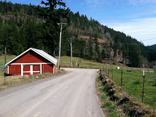
After about 4 miles of downhilling on dirt, you dump out onto the pavement and go left at the little red barn onto Black Diamond Road:


If you like descending, this is the best part of the whole ride. A very fast (but not crazy fast) eye-watering descent on smooth pavement losing the rest of the altitude you gained on the way to Lake Dawn.

The first time I rode this stretch, it was a beautiful day in August, my legs were feeling great, and I was literally laughing out loud. Wow, fun. Damn, it's good to be alive.  Shift into your biggest chainring and littlest cog and crank on it to average 30mph for the next 3.4 miles, or just mostly coast and rest your legs.


Black Diamond Road eventually levels out and turns right onto Olympic Hot Springs Road, and then a quick left onto HWY 101, where you immediately cross over the old Elwha River Bridge. (Note for alternate "Less Climbing" riders: this is where we re-group with the folks who opted for the flatter alternate 1st leg of the ride.)  Incidentally, this is smack-dab in the middle of the famous Elwha Dams Removal Project and if you look to your right as you cross the bridge, that's where Lake Aldwell used to be.  A river runs through it, these days.

There's not much shoulder on that bridge, and your best strategy here is to try to time your crossing of this bridge so you don't have to share it with any westbound motor vehicle traffic.


You're now heading west on Hwy 101, and starting a gradual 4 mile ascent to Granny's Cafe, everyone's favorite spot to stop and grab a soft-serve cone and/or lemonade. It's probably too early for lunch, isn't it? Too bad, they make some pretty good burgers here. Oh, man. It's not too early for pie, is it...?

Granny's Cafe to Log Cabin Resort


(Go right on East Beach Road)
Now that you're tanked up on pie and ice cream, continue west on HWY 101 (4) miles past Shadow Mountain Grocery (another chance for ice cream and snacks, if you didn't stop at Grannys) and another mile to East Beach Road.  There, you go right off the highway up that short sharp hill (probably the last time you'll need your small chain ring, if you're riding a triple) and carefully proceed a couple miles to Log Cabin Resort. We say "carefully," because at this point, you rarely have more than a couple of inches of shoulder, and the road twists and winds a lot. But it's only for a couple miles, on a lightly traveled road.

(Och, how'd we end up in Scotland?  Oh, right, that's Loch Crescent.)


Log Cabin Resort, for anyone who wants to see it, has a place to dip your toes in the lake if you're ready for a respite, and to check it out for a future vacation stay, but they aren't usually open for business until  Memorial Day weekend.


It's only about a 100 yards down that driveway on the left if you want to take a peek.  A good place to camp out if you come back with your mountain bike and want to ride the Olympic Adventure Trail, which has several segments in the immediate neighborhood.


Log Cabin Resort to Joyce (the long way)

From the Log Cabin Resort driveway, continue west on East Beach Road and you'll immediately pass Lady of the Lake Lane and then go left at the next road after that, where you will see a sign pointing the way to the Spruce Trail (a terrific place to ride your cross or mountain bike)
(Go left where it points to Spruce Railroad Trail)
 Technically,  even though you've turned off the main road, you'll still be on East Beach Rd. You'll descend down to lake level and come to a one-lane bridge over the Lyre River. Just before you get to the bridge, hang a right onto this unmarked dirt road.
Follow this for about .75 miles of general bumpiness to the yellow gate (no motorized vehicles beyond this point - except logging equipment!) When you go around the gate, you're not trespassing; it a legal bike/hike/horse trail, courtesy of Green Crow Logging Co. 


 Stay on what looks like the main road, as there are a few spur roads that take you off uphill into what are mostly dead ends. (Come back another day and enjoy those on your mountain bike.)

(Spring 2014 Update:  this is one of the places they've resurfaced the road recently, with a heavier grade of gravel.  For the next couple of miles be ready to check your speed, in short, sporadic patches, some of it can be slow going.)

This dirt road continues about 3 miles or so after the yellow gate.  It winds around through the woods a bit with a little fast descending at the end (if you dare) before it dumps out onto HWY 112. Turn right and follow HWY 112 about 4 or 5 miles to the Joyce General Store. This stretch is completely flat and very straight but has extremely skimpy shoulders.  If it's raining, you will hate this part of the ride, with every passing logging truck blasting you with a 60mph wall of filthy road spray.  Some will blast their horns at you for good measure.   Because of the high speed traffic and lack of shoulders, this section of HWY 112 is kind of marginal riding under the best conditions, but downright horrible when it's wet.

Sunday, April 15, 2012

Joyce General Store to Crescent Bay/Tongue Point

Joyce General Store; same location for 103 years.

Gotta check this place out; it's a bit of Americana that has almost completely disappeared nowadays. They don't make 'em like this any more. Stop in and buy some snacks and sugar water.  Check out the bulletin board to find out where you can buy next fall's firewood, a large reptile cage with heat lamp, or a yellow '87 Trans Am (85% complete! Best Offer!). Or farm-fresh free-range eggs.
(Caution!  Bicycle Riders!  Hey!  That's us!)
Take the little road that goes (North) behind Joyce Gen Store, and a right at the Y takes you to Crescent bay in a couple miles, of fairly fast rolling up and down country road, with a sharp descent to water; careful, it's steep and twisty on the way down that last little bit.


 Here's Crescent Bay.  You'll pedal on the flat road next to the bay for about a mile to get to Salt Creek Recreation and Wildlife Area.  Not a bad place to stop and lock up and take a stroll down the beach.  Or ride your bike down the beach; I didn't see any signs specifically prohibiting it.  If you stay close to the waterline, the fine sand is usually hard and rideable even on skinny tires.  (here's the parking lot and restrooms)

Or if you want to check out the Salt Creek / Camp Hayden campground, that's another minute or two up the road.  Day use is free of charge.
Ride into the park for picnic tables, restrooms, etc. and go left as far as you can into the camping area through the trees, and there's a staircase going down to Tongue Point, where you can wander around the tidepools looking at sea life (when the tide is low enough).  Not really a good place for biking shoes, unless you like to get them gummed up with seaweed and dirt and rocks. (Edit: check tide tables if you are considering this side trip.  A zero or minus tide is the best time to visit.)

(This is looking out over Tongue Point at a fairly high tide, mostly submerged.  Those little islands you see going up the middle are the higher points that you climb around on to get to the tidepools that are so much fun to poke around in at a minus tide.)

(There is a deer in this photo, can you find it?)
Camp Hayden, the site of Salt Creek Recreation Area is an old WWII military base with bunkers and big guns to turn back the Japanese warships that were just constantly trying to poke their noses in the the Juan de Fuca Straight back in the day.


You can walk or ride out to check out  few bunkers while you're here, with several spooky, dark, dank inner chambers to poke around in, and some disarmed (I hope) ordnance casually strewn about.

(The shells are disarmed, but my custom bike is da bomb.)

Saturday, April 14, 2012

Tongue Point to Elwha Bridge

Leaving the Tongue Point Wildlife Area (or Camp Hayden State Park) you're heading south on camp Hayden Road. You gain a couple hundred feet in 3.5 miles, take a left onto Hwy 112 at the Salt Creek Inn (lunch, dinner, cocktails) and go a hair over 5 miles to Elwha River Road, take a left there and downhill a fast one-mile swoop to the new Elwha Bridge, turn right onto the gated dirt road just before you cross the bridge, this takes you down to the bike/pedestrian bridge under the upper deck cars & trucks bridge.

Elwha Bridge to Port Angeles Marine Drive

(Elwha Bridge, viewed from the east)
After you cross under the Elwha Bridge, you ride down a ramp which dumps you (right) out onto a nice smooth and flat couple miles of sylvan bike trail winding through the woods to Kaycee Way, then crossing Lower Elwha Rd, staying on the bike path crossing West 18th Street, 14th Street

(Trail NOT closed.  Thank you Olympic Trails Coalition.)
and following the old Milwaukee Railroad grade (now MUP)  all the way back into the western neighborhoods of Port Angeles.  The MUP ends  in the residential nabe of South Milwaukee Avenue which dumps out onto 4th Street, continues
(Seems like there's a lotta junky old bikes in this town)
past Crown Park (nice view of the mill and harbor) and right after that, a short steep drop down Hill Street to Marine Drive.

Past the paper mill out to the end of Ediz Hook...


At the bottom of Hill Street, go left on the sidewalk waterfront trail past the mill complex (trail is clearly marked) and a couple more miles of flat along the skinny sandspit we call Ediz Hook, all the way out to the gate of the Coast Guard station.  (But not beyond, I don't think they allow casual visitors on base, especially not a bunch of dirty hippies on bicycles.)
(Surely, you don't mean us, my good man?)

Then double back along the hook to the waterfront trail, past Castaways Restaurant, the boat haven and left at Tumwater Street through the Westport Shipyard

  for a quick one-minute drive-by tour of the luxury yacht building business in Port Angeles. 
You can continue left along sidewalk (this is technically the Waterfront Trail) to the Coho Ferry dock where you turn right on Laurel Street to get back to the hotel. The closer you stay to the water, the farther away from downtown traffic you'll be. Or if you want to go back out on the street, just take a left on Laurel to get back to the hotel.

Once again, click here for our Veloroutes map or click here for our same route on Bikely. Both show the entire route and can be viewed at any level of zoom on your computer or smart phone. Or printed out in sections if you like, using whichever print screen function you have on your computer.

Manager's reception after the ride

I'll get a few cases of good beer, some wine, and snacks and we'll have a hosted bar back at the hotel after the ride, say around 4 or 5ish, depending on when we get back.

Dress:  Casual and sweaty.

Make your reservation for a room

Just call our toll free number 1-866-688-8600 any time between 9am and 10pm if you'd like to book a room.  Say you'd like the "Downtown Hotel Metric Century Discount" of $5/night for your stay.   Rooms start at $45/night.  Offer good that Friday through Sunday weekend.

Tell them Tim sent you.